


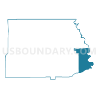
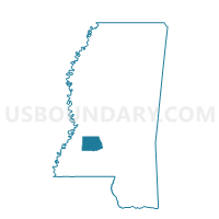
Georgetown South Voting District, Copiah County, Mississippi
About
Outline

Summary
| Unique Area Identifier | 605260 |
| Name | Georgetown South Voting District |
| County | Copiah County |
| State | Mississippi |
| Area (square miles) | 44.27 |
| Land Area (square miles) | 43.78 |
| Water Area (square miles) | 0.49 |
| % of Land Area | 98.90 |
| % of Water Area | 1.10 |
| Latitude of the Internal Point | 31.80690850 |
| Longtitude of the Internal Point | -90.17171420 |
Maps

Graphs
Select a template below for downloading or customizing gragh for Georgetown South Voting District, Copiah County, Mississippi


Neighbors
Neighoring Voting District (by Name) Neighboring Voting District on the Map
- Bridgeport Voting District, Simpson County, MS
- Fork Church Voting District, Simpson County, MS
- Georgetown North Voting District, Copiah County, MS
- New Hebron Voting District, Lawrence County, MS
- Oma Voting District, Lawrence County, MS
- Shady Grove Voting District, Copiah County, MS
- Strong Hope-Union Voting District, Copiah County, MS
Top 10 Neighboring County Subdivision (by Population) Neighboring County Subdivision on the Map
- District 2, Copiah County, MS (7,165)
- District 5, Simpson County, MS (6,256)
- District 1, Copiah County, MS (5,658)
- District 4, Simpson County, MS (5,193)
- District 2, Lawrence County, MS (2,645)
- District 4, Lawrence County, MS (2,569)
Top 10 Neighboring Place (by Population) Neighboring Place on the Map
Top 10 Neighboring Unified School District (by Population) Neighboring Unified School District on the Map
- Simpson County School District, MS (27,503)
- Copiah County School District, MS (18,369)
- Lawrence County School District, MS (12,929)
Top 10 Neighboring State Legislative District Lower Chamber (by Population) Neighboring State Legislative District Lower Chamber on the Map
Top 10 Neighboring State Legislative District Upper Chamber (by Population) Neighboring State Legislative District Upper Chamber on the Map
- State Senate District 39, MS (56,401)
- State Senate District 35, MS (55,228)
- State Senate District 36, MS (50,974)
Top 10 Neighboring 111th Congressional District (by Population) Neighboring 111th Congressional District on the Map
Top 10 Neighboring Census Tract (by Population) Neighboring Census Tract on the Map
- Census Tract 9504, Simpson County, MS (7,759)
- Census Tract 9503, Simpson County, MS (6,181)
- Census Tract 9505, Copiah County, MS (6,087)
- Census Tract 9502, Copiah County, MS (4,924)
- Census Tract 9602, Lawrence County, MS (4,551)
- Census Tract 9601, Lawrence County, MS (4,249)
Top 10 Neighboring 5-Digit ZIP Code Tabulation Area (by Population) Neighboring 5-Digit ZIP Code Tabulation Area on the Map
- 39059, MS (12,073)
- 39083, MS (10,626)
- 39191, MS (8,074)
- 39654, MS (5,635)
- 39140, MS (2,250)
- 39149, MS (1,649)
- 39082, MS (1,312)
- 39078, MS (755)